Planning's Alex Zendel Trailblazes in Knoxville's Urban Wilderness
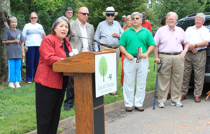
When a crowd of 200 gathered for the opening of the South Loop of Knoxville's Urban Wilderness (KUW) Trail on August 15, Planning staffer Alex Zendel was there to celebrate. And it wasn't his first time on the scene. He'd been there many times gathering data to help others enjoy the great outdoors.
It took a cast of hundreds to build an intricate trail system like the KUW. Individuals, organizations, government agencies, and businesses contributed time, funds, expertise, and materials to make the vision a reality. Planning is particularly proud of the efforts of its Geographic Information Systems Analyst, Alex Zendel.
Many of the trails in the Hastie Natural Area, Ross Marble Quarry, and Forks of the River Wildlife Management Area have been there for years, but as Alex said, "unless they had a guide or were willing to get lost, many people didn't want to venture in there."
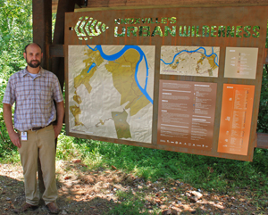
In April 2010, Alex started mapping trails for AMBC using the GPS feature on his phone while riding his bike. He imported that information into a computer mapping program, then tackled the job of cleaning the data and adding details like trail name, surface type, and width.
By July 2011, as new trails were nearing the final planning and design phases to complete KUW's South Loop, he'd produced a promotional map for the system.
Construction continued on the last connecting trails in January 2012, and a team began designing a kiosk and signage network to guide users through the trail system. Team members represented The Legacy Parks Foundation, the City of Knoxville Parks Department, Knox County Parks and Recreation Department, AMBC, Ijams Nature Center, and even former Planning Chair Trey Benefield. Alex contributed his expertise, keeping the system map updated as new segments were finished, and working with Robin Easter Design to ensure his map fit seamlessly into the signage scheme.
While the design of the map was official Planning business, a substantial portion of Alex's work was completed on personal time. He estimates he's donated nearly 80 hours to several projects related to this trail system, and that doesn't include time spent on his bike gathering data. But, he did see a personal benefit to all that riding.
"My quality of life and physical health substantially improved since I started biking these trails in April 2010. I hope these maps will encourage people to get out and explore the urban wilderness on their own by bike or foot. Exercise doesn't feel like a chore when you're exploring and having fun," he said.
Posted 8-22-2012, written by Sarah Powell